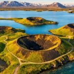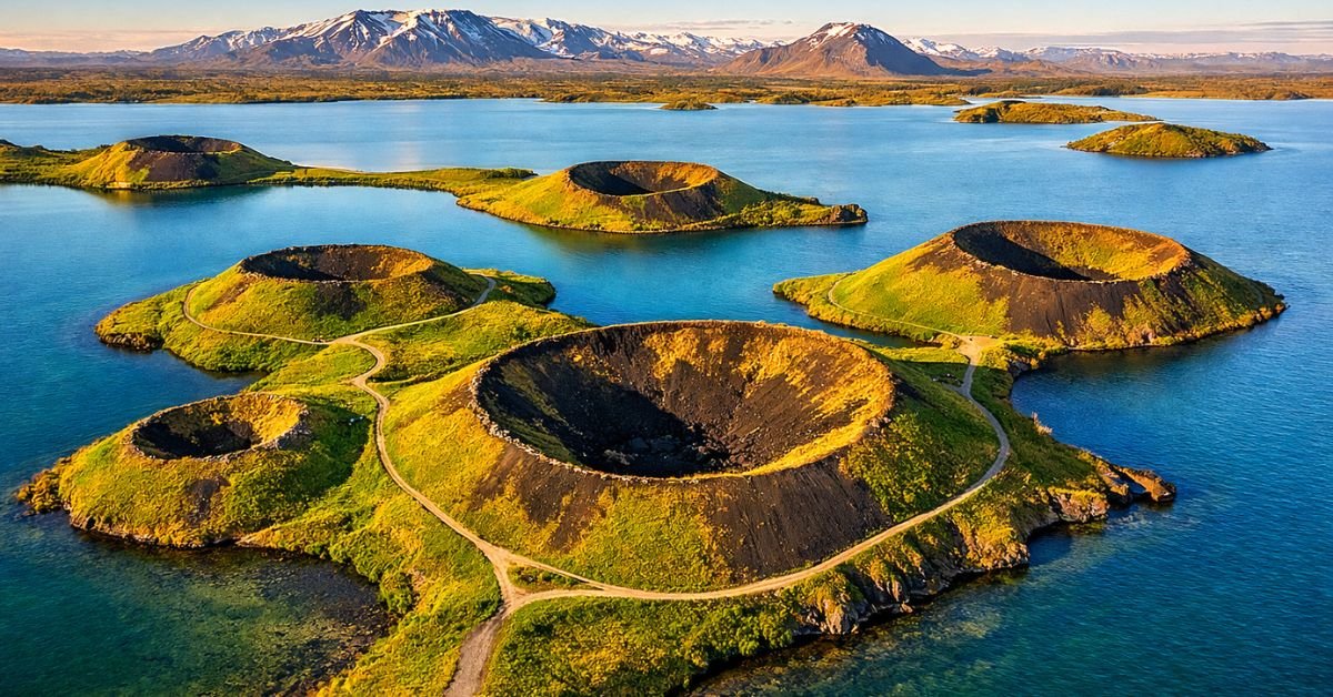
Standing on the southern shore of Lake Mývatn, you look out across a landscape of grassy, bowl-shaped mounds rising from the earth like something a giant scooped out and flipped upside down. These are the Skútustaðagígar pseudocraters — and despite looking exactly like volcanic craters, not a single one of them ever erupted.
That contradiction is precisely what makes Skútustaðagígar one of the most geologically fascinating sites in Iceland. These formations, also known as rootless cones or rootless craters, were born from a violent clash between searing lava and waterlogged ground roughly 2,300 years ago. Today, they sit quietly beside Route 1, the Ring Road, covered in soft grass and surrounded by some of the richest birdwatching habitat in Northern Europe.
Whether you’re driving the Diamond Circle, day-tripping from Akureyri, or combining the Skútustaðagígar craters with the nearby Hverir geothermal area for a full day in the Mývatn region, this guide covers everything: the geology behind these pseudo craters, what the trails look like, the birdlife you’ll encounter, nearby attractions including the Hverir hot springs, and the practical details that make the difference between a good visit and a great one.
What Are the Skútustaðagígar Pseudocraters? (And Why “Pseudo”?)
The name Skútustaðagígar translates loosely to “the craters at Skútustaðir,” the nearby farmstead on the southern shore of Lake Mývatn. But calling them craters requires an asterisk, because these formations break the rules of conventional volcanism.
A standard volcanic crater forms when magma forces its way upward through a conduit — a pipe connecting a subsurface magma chamber to the surface. Pressure builds, the surface ruptures, and lava, gas, and rock blast out. The crater is the scar left behind.
The Skútustaðagígar pseudo craters skipped that entire process. There is no conduit. No magma chamber directly underneath. No eruption in the traditional sense. Instead, they formed through a sequence of violent steam explosions that occurred entirely at the surface, which is why geologists also refer to them as rootless cones — they have no “root” connecting them to the planet’s interior plumbing.
The “pseudo” label isn’t a demotion. It’s a technical distinction that actually makes these features more interesting than ordinary craters, because the forces that shaped them are far more unusual.
How Did the Skútustaðagígar Craters Form? The Geology Explained
Around 2,300 years ago — roughly the same era the Greek mathematician Archimedes was alive — two volcanic fissures called Lúdentaborgir and Þrengslaborgir erupted east of what is now Lake Mývatn. The lava flows from these eruptions were extensive and fast-moving, spreading across the landscape toward the low-lying wetlands surrounding the lake.
Here’s where the story gets dramatic.
The Mývatn area at that time was a marshy expanse of shallow water, saturated sediment, and boggy ground. When the superheated basaltic lava — temperatures well above 1,000°C — flowed over this waterlogged terrain, the water beneath it had nowhere to go. It couldn’t escape sideways. The weight of the cooling lava crust above it acted like a pressure cooker lid.
Trapped water flashed to steam. Pressure built rapidly. And then: explosion.
These phreatic (steam-driven) blasts punched upward through the still-molten lava, hurling fragments of rock, scoria, and spatter into the air. The ejected material landed around the vent, building up the rim of what would become a crater. If multiple explosions occurred at the same spot, the accumulated debris formed a convincing bowl shape — nearly indistinguishable from a real volcanic crater to the untrained eye.
If only a few explosions occurred, the result looked more like a grassy mound or hill rather than a defined bowl. That’s why, as you walk among the Skútustaðagígar pseudocraters today, you’ll see a variety of shapes: some are perfect crescent-shaped bowls, others look like lopsided hills, and a few are spiky lava cones still bearing their original spatter and scoria.
The Skútustaðagígar cluster is unique because the pseudocraters here sit on a scoria mound — an unusual foundation for this type of formation. The area contains more than 50 individual pseudocraters, making it the largest and most spectacular concentration of rootless cones in Iceland. The entire 70-hectare site was designated a protected natural monument in 1973 and is now part of the UNESCO Global Geopark around Lake Mývatn.
Pseudocraters vs. True Volcanic Craters: A Side-by-Side Comparison
Understanding the difference between the Skútustaðagígar pseudo craters and conventional volcanic craters clarifies why geologists find this site so valuable. Here’s a direct comparison:
| Feature | Pseudocraters (Rootless Cones) | True Volcanic Craters |
|---|---|---|
| Magma conduit | None — “rootless,” no connection to a magma chamber | Direct conduit from subsurface magma chamber |
| Formation trigger | Lava-water interaction; steam explosions at the surface | Magmatic eruption from below |
| Typical diameter | A few meters to ~50 meters | Tens of meters to several kilometers |
| Lava production | Do not erupt their own lava | Erupt lava, ash, and pyroclastic material |
| Clustering pattern | Small, irregular clusters, not aligned along fissures | Often aligned along volcanic rift zones |
| Rarity | Uncommon globally; Iceland is the primary location | Found worldwide along tectonic boundaries |
| Known extraterrestrial examples | Identified on Mars (Elysium Planitia, Athabasca Valles) | Found on the Moon, Mars, Venus, and Io |
This comparison highlights something remarkable: pseudocraters are among the rarest volcanic landforms on Earth, yet they appear abundantly on Mars. More on that connection below.
The Mars Connection: Why NASA Studies Iceland’s Pseudocraters
This is where the Skútustaðagígar pseudocraters go from interesting Icelandic attraction to globally significant geological site.
High-resolution images from NASA’s Mars Global Surveyor and later the Mars Reconnaissance Orbiter revealed cone-shaped structures scattered across volcanic plains in the northern hemisphere of Mars — particularly in areas like Elysium Planitia, Marte Valles, and Amazonis Planitia. These Martian cones share several defining characteristics with Icelandic pseudocraters: they cluster in small, irregular groups, they sit on top of lava flows rather than producing lava themselves, and they have basal diameters consistent with the rootless cones at Mývatn.
Research published through NASA’s Technical Reports Server directly compared Icelandic rootless cones to these Martian features, using field studies at Mývatn as the terrestrial analog. The implication is significant: if the Martian structures truly are pseudocraters, they represent evidence that shallow ground ice or liquid water existed near the equator of Mars at the time the lava flows occurred — potentially as recently as 10 million years ago in geological terms.
A 2025 study from Niigata University took this further, conducting laboratory experiments that simulated rootless cone formation under both Earth and Mars conditions. The research found that Martian pseudocraters would require significantly less water to form — roughly four to sixteen times less — due to the planet’s lower gravity and atmospheric pressure.
For visitors standing among the Skútustaðagígar craters, this context reframes the experience entirely. You’re not just looking at a quirky Icelandic landform. You’re standing on one of the best Earth-based analogs for understanding whether Mars once harbored water near its surface.
Exploring Skútustaðagígar: Trails, Terrain, and What to Expect
The Skútustaðagígar pseudocraters are among the most accessible geological attractions in North Iceland. The site is located directly off Route 1 on the southern shore of Lake Mývatn, with a parking area and clearly marked trailheads.
The Short Trail (1.5 km Loop)
This easy loop takes 30 to 45 minutes and winds through the western cluster of pseudocraters. The path is well-maintained, mostly flat, and suitable for families with children. Informational boards along the route explain the geological processes behind the formations. From several points, you get panoramic views across Lake Mývatn — Iceland’s fourth-largest lake — with the pseudocraters rising in the foreground.
The Long Trail (3 km Loop)
For a deeper exploration, this trail takes one to two hours and covers a broader section of the crater field. You’ll pass a wider variety of formations — from smooth, grass-covered mounds to rough-textured lava cones with exposed spatter. The route also offers better vantage points for photography, particularly in morning or late-afternoon light when shadows define the craters’ contours.
Terrain Notes
The trails are not paved but are well-trodden and clearly marked. Sturdy walking shoes are recommended. The terrain is uneven in places, especially on the long trail. Sheep graze the area freely, so expect to share the path. There are no entrance fees, though parking may require payment during peak season.
Birdwatching at Skútustaðagígar: Species and Seasons
Lake Mývatn’s name means “Midge Lake” — a reference to the enormous clouds of midges that breed here each summer. Those midges, while annoying for visitors, are a critical food source that supports one of Europe’s most diverse freshwater bird populations. And the wetlands surrounding the Skútustaðagígar craters sit right in the middle of it.
Notable species you may encounter around Skútustaðagígar and the adjoining lake shore include the Barrow’s Goldeneye (which breeds exclusively in Iceland within Europe), the Harlequin Duck in the upper Laxá River, large flocks of Tufted Ducks, Eurasian Wigeons, and Greater Scaup. The Red-necked Phalarope is a frequent sight swimming close to shore.
On the land surrounding the pseudocraters, look for Meadow Pipits, Northern Wheatears, and White Wagtails. Merlins hunt small songbirds in the area, and Short-eared Owls make occasional appearances. In rare cases, visitors have spotted the Gyrfalcon — Iceland’s largest bird of prey — hunting over the crater field.
Peak birdwatching season runs from May through August. A bug net or head net is strongly recommended during June and July, when the midge population reaches its zenith.
Skútustaðagígar and Hverir: Combining Two Mývatn Highlights
One of the most common search pairings — “Skútustaðagígar hverir” — reflects a practical reality: these two sites are close together and make a natural combined visit. The Hverir geothermal area (also called Námafjall Hverir or Hverarönd) lies approximately 12 kilometers northeast of Skútustaðagígar, about a 12-minute drive along Route 1.
What Is Hverir?
Hverir is a high-temperature geothermal field on the east side of Námafjall mountain, part of the active Krafla volcanic system. The landscape is stark and barren — no vegetation survives the acidic, sulfur-laden soil. Instead, you’ll find bubbling grey mud pots, hissing steam vents (fumaroles), and ground painted in vivid shades of yellow, orange, red, and green by mineral deposits.
The smell hits immediately: hydrogen sulfide, the classic “rotten egg” scent of geothermal activity. The experience is intense and deeply alien — many visitors describe it as walking on another planet.
A Suggested Day Itinerary: Skútustaðagígar + Hverir + More
Here’s a practical routing for a full day in the Mývatn area, whether you’re driving the Ring Road or based in Reykjahlíð:
Morning: Start at Skútustaðagígar. Walk the short or long trail while the light is soft and tour buses haven’t arrived yet. Allow 45 minutes to 2 hours depending on your pace and interest in birdwatching.
Late Morning: Drive to Dimmuborgir, the extraordinary lava fortress formation on the eastern shore. The walking paths here wind through towering lava pillars and arches. Allow 1 to 1.5 hours.
Midday: Continue to Grjótagjá cave, the small geothermal cave with a stunning blue hot spring inside (no bathing — the water temperature has been too high since the 1970s Krafla eruptions). A quick 20-minute stop.
Early Afternoon: Head to Hverir/Námafjall. Walk the geothermal field (15 to 30 minutes for the main loop). If you have energy, hike partway up Námafjall ridge for sweeping views back over the steam vents and across to Lake Mývatn.
Afternoon: Soak at the Mývatn Nature Baths — North Iceland’s answer to the Blue Lagoon, set in a lava field with views of the surrounding mountains. Less crowded and less expensive than its southern counterpart.
This itinerary pairs the green, life-filled landscape of Skútustaðagígar with the stripped, volcanic intensity of the Hverir hot springs — two completely different expressions of the same underlying geological engine.
Myths vs. Facts About Skútustaðagígar
Misconceptions about this site are common, especially given how unusual the formations look.
Myth: The Skútustaðagígar craters are volcanic craters formed by eruptions. Fact: They are pseudocraters — rootless cones formed by steam explosions when lava flowed over waterlogged ground. No magma ever erupted directly from these formations.
Myth: Pseudocraters are common around the world. Fact: They are actually quite rare globally. Iceland is the primary location for well-preserved examples, with smaller occurrences in Hawaii. The phenomenon is far more common on Mars than on Earth.
Myth: The craters formed during the last ice age. Fact: The Skútustaðagígar pseudocraters are approximately 2,300 years old, formed during eruptions from the Lúdentaborgir and Þrengslaborgir fissures. Iceland was already settled by the Norse before these craters had existed for even a thousand years.
Myth: Hverir and Skútustaðagígar are the same type of geological feature. Fact: They are products of related but distinct processes. Skútustaðagígar’s pseudocraters resulted from lava-water interaction. Hverir’s fumaroles and mud pots are driven by ongoing geothermal heat from the Krafla system heating groundwater. One is a fossil event; the other is actively happening right now.
Myth: You need to be a serious hiker to visit. Fact: The short loop trail at Skútustaðagígar is 1.5 km, mostly flat, and takes 30 to 45 minutes. It’s suitable for families, older visitors, and anyone in reasonable walking condition.
Practical Visitor Information (2026)
Location: Southern shore of Lake Mývatn, North Iceland. GPS coordinates: approximately 65.5672° N, 17.0211° W.
Getting There: Skútustaðagígar sits directly adjacent to Route 1 (the Ring Road). From Akureyri, it’s about 90 km east (roughly 1 hour by car). From Reykjavík, the drive is approximately 470 km (around 6 hours). For those without a car, Bus 56 from Akureyri runs to the Skútustaðir stop.
Entry Cost: Free to visit. Parking fees may apply during summer.
Time Needed: 30 minutes for the short trail; 1 to 2 hours for the long trail and thorough exploration.
Best Season: June through August for the best weather, longest daylight, and peak birdwatching. September offers fewer crowds and autumn colors on the crater slopes. Winter visits are possible but trails may be icy or snow-covered.
Nearby Accommodation: Skútustaðir Farm House (directly adjacent to the craters), Sel Hotel Mývatn, Fosshotel Mývatn, Icelandair Hotel Mývatn, and Dimmuborgir Guesthouse are all within a short drive.
Dining Options: Café Dimmuborgir, Vogafjós Farm Resort (try the fresh mozzarella made on-site), and Gamli Bistro are popular local eateries.
Expert Perspective: Why Skútustaðagígar Deserves More Attention
Having spent time studying volcanic landscapes across Iceland, what strikes me about Skútustaðagígar is how chronically underestimated it is. Most Ring Road itineraries treat the pseudocraters as a “quick stop” — 20 minutes, snap a photo, move on. That’s a mistake.
The site rewards patience. The formations change character depending on where you stand, what time of day it is, and which direction you approach from. The interplay between the grassy craters, the surrounding wetlands, and the lake itself creates a landscape that shifts with the weather — moody under overcast skies, almost idyllic in golden-hour light.
From a geological education standpoint, Skútustaðagígar is one of the clearest, most accessible demonstrations of phreatic volcanic processes anywhere on Earth. The fact that NASA uses this site as a reference point for interpreting features on Mars should tell you something about its scientific stature. And yet, it remains overshadowed by flashier Mývatn attractions like Hverir and Dimmuborgir.
If you’re visiting the Mývatn area, give the Skútustaðagígar pseudocraters the time they deserve. Walk the long trail. Bring binoculars for the birds. Read the informational boards. And take a moment to process the fact that the ground you’re standing on was once a boiling marsh where lava and water fought a brief, explosive war — and water, remarkably, won.
FAQ: Skútustaðagígar Pseudocraters
What does Skútustaðagígar mean in English?
The name translates roughly to “the craters at Skútustaðir.” Skútustaðir is the farmstead located on the southern shore of Lake Mývatn, near the pseudocrater field. “Gígar” is the Icelandic word for craters. The site is sometimes spelled Skútustaðagígar or Skútustaðargígar in different sources.
Are the Skútustaðagígar craters real volcanic craters?
No. Despite their crater-like appearance, the Skútustaðagígar formations are pseudocraters — also called rootless cones. They were created by steam explosions when molten lava flowed over waterlogged terrain approximately 2,300 years ago. Unlike true volcanic craters, they have no magma conduit beneath them.
How far is Skútustaðagígar from Hverir geothermal area?
The two sites are about 12 kilometers apart (roughly 12 minutes by car along Route 1). Many visitors combine both into a single half-day itinerary while exploring the Mývatn region. Skútustaðagígar offers green, grassy landscapes and birdlife, while Hverir delivers barren, sulfurous geothermal terrain — two dramatically different experiences within easy reach of each other.
Is Skútustaðagígar suitable for children?
Yes. The short loop trail is 1.5 km, mostly flat, and well-marked with educational signage. It takes about 30 to 45 minutes and is appropriate for children who can handle light walking on uneven ground. There are no dangerous drop-offs or restricted areas along the main path.
Why do scientists compare Skútustaðagígar to features on Mars?
NASA research has identified cone-shaped formations on Martian lava plains that closely resemble Iceland’s pseudocraters in size, shape, and clustering patterns. Scientists use the Mývatn rootless cones as a terrestrial reference for interpreting these Martian features, which may indicate the past presence of near-surface water or ice on Mars.
When is the best time to visit Skútustaðagígar?
Summer (June through August) offers the best combination of mild weather, long daylight hours, and peak birdwatching activity. Early mornings are ideal for avoiding tour-bus crowds and capturing the best photography light. Autumn (September) brings fewer visitors and beautiful color on the grassy crater slopes. Winter visits are possible but conditions vary.
Looking Ahead: Skútustaðagígar in a Changing Landscape
Iceland’s geological story is never finished. The Krafla volcanic system that drives the Mývatn region’s geothermal activity remains active, and the broader tectonic forces pulling North America and Eurasia apart along the Mid-Atlantic Ridge continue to reshape the landscape at a rate of roughly two centimeters per year.
For Skútustaðagígar specifically, conservation remains a priority. The site’s 1973 designation as a natural monument and its inclusion within the UNESCO Global Geopark around Lake Mývatn provide formal protections, but increasing visitor numbers — part of Iceland’s broader tourism growth — require ongoing trail maintenance and habitat management, particularly for the nesting waterbirds that depend on the surrounding wetlands.
The scientific relevance of these pseudocraters is also growing. As Mars exploration advances and new high-resolution surface data arrives from missions like the Mars Reconnaissance Orbiter and future landers, the Skútustaðagígar rootless cones will likely remain a key reference site for planetary scientists working to understand lava-water interactions beyond Earth.
Whether your interest is geological, ecological, photographic, or simply the pleasure of walking through a profoundly strange and beautiful landscape, Skútustaðagígar delivers. Pair it with the Hverir geothermal area and the other Mývatn attractions, and you’ve got one of the most rewarding days available on Iceland’s Ring Road.
Emma Clarke is a content writer at Gaukurinn.is, specializing in celebrity news, pop culture, movies, and music. With a strong focus on accuracy and trending topics, she creates engaging and well-researched articles that keep readers informed and entertained.
Emma follows trusted sources and editorial standards to ensure content is reliable, relevant, and up to date. Her goal is to deliver clear, valuable information that readers can trust.